NEW!
- The 1829 Parson and White Directory for Troutbeck.
- Census data for 1841.
- Census data for 1851.
- Census data for 1871.
Longmire is in fact a small hamlet and one of a group of old settlements which are collectively known as Troutbeck. The Troutbeck valley leads North West (ish) from Windermere. If you travel up the valley it leads to Kirkstone Pass and thence over to Ullswater. Kirkstone Pass is frequently mentioned in travel reports on the radio and TV during winter as it is subject to closure when we get snow.
The Troutbeck valley is very picturesque, the photos here scarcely do it justice but at least those people who have not yet had the chance to visit can treat them as an appetiser.
The Troutbeck area forms a basis for History studies at our school as there are many old and interesting dwellings. The two most well known ones are 'Townend' and the Mortal Man. The first of these is in the hands of the National Trust, maybe further information about it is available somewhere else on the web. The second is a fine public house.
So much for the text so far, here come the pictures.....
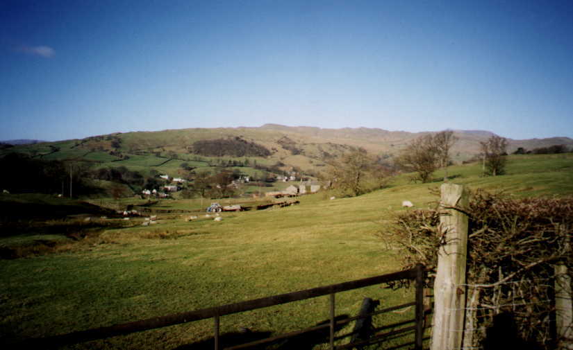
This picture was taken at the southern end of a track which is marked on my Ordnance Survey map as 'Longmire Lane'. The picture is taken roughly at Longitude 2 degrees 54 minutes East, Latitude 54 degrees 24 minutes North and we are looking more or less NorthWest, across the Troutbeck valley. The grey buildings in the centre, just to the right of the tractor, are named on my map as 'Low Longmire'. The far buildings are on the west side of the valley, where the main Troutbeck settlement is strung out over about a mile. I think the bits you can see are the areas known as Townend and Low Fold. (It is a bit confusing that there is a house called Townend within the area called Townend.)
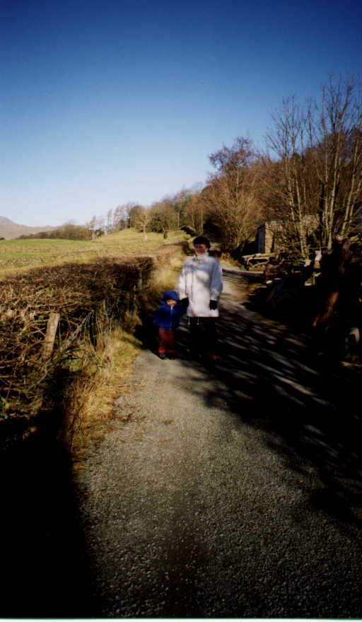
This second picture is taken from the same place, this time looking along Longmire Lane itself, basically looking North. The two shady characters, by which I mean the characters in the shade, are my son Thomas and wife Mandy. About half a mile further up the track lies a puddle into which Thomas deposited himself, cutting short our Longmire expedition. However, that was not before I took the next picture...
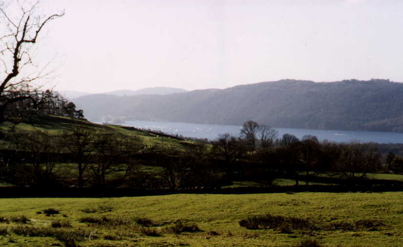
....which is taken from a little further up Longmire Lane, this time looking back South to Windermere. If this comes out well enough on your monitor you will be able to make out the regular Sunday morning sailing races taking place. For those that are interested, our school lies somewhere down there in the dip between the prominent tree centre right, and the water.
Well that is about it for now, if time matches enthusiasm or if I can get some pupils interested, I will try to add more later.
As promised, here is some 'more later'....
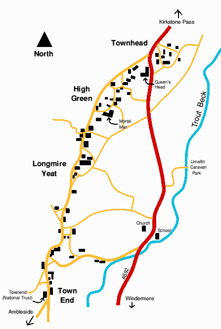
The following is my attempt to map the Troutbeck area. It is obviously not to any accurate scale although to give you a rough idea, from Town End to Townhead is about 1 mile. You can see from the map how the 'village' of Troutbeck is made up of the hamlets Town End, Longmire Yeat, High Green and Townhead. It is also interesting to see the network of little lanes which cross the valley and connect the various groups of buildings. The main A592 road from Windermere to Ullswater is shown. On my original it is red but it may look a different colour on your browser. The road through the village, shown in orange (ish) is quite narrow and for the most part is not wide enough for two vehicles to pass easily.
All the buildings in Troutbeck are constructed from slate which is quarried nearby, though there are not so many working quarries now as there once were. There are some very old houses, probably originally built for yeomen. (Yeoman was a term used after the 15th century to describe a man who owned a small estate, a class of person below a gentleman but above an ordinary labourer. We might compare them to todays 'middle class' rather than 'working class'.)
 There are many interesting buildings in Troutbeck but possibly the finest is Townend. It was built in 1626 by a man called george Browne. He was a wealthy yeoman farmer. His family were well established in the village. The house remained in the Browne family for many generations. In 1947 it became a property of the National Trust who are responsible for its upkeep and preservation. It is open to visitors on Summer afternoons and is well worth a visit as it is maintained as it would have been lived in many years ago. For example the house has no electricity, and so it is lit only by natural light coming in through the mullioned windows. Many of the walls are covered not with wallpaper or paint, but with carved wooden panelling. All of the wooden furniture is that which the Browne family built up over many years and includes chairs used by the children and a lovely carved cradle. You can also see many of the old kitchen tools and generally get a real feel for what life must have been like years ago. It is an incredible record of one family's history. Even the garden outside is laid out and planted as it was in the 19th century, by working from an old photograph.
The next picture is of Townend
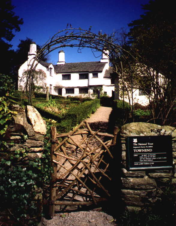
Opposite Townend is a good example of a 17th century barn which was also owned by the Brownes. This is where they stored the wool fleeces waiting to be sold to merchants. The barn has what looks like a covered balcony but is called a spinning gallery. (When I find out exactly what a spinning gallery was I will explain it here.) The barn is not open for the public to enter.
Whilst we are at the South end of the settlements, a quick mention of the church. You will notice from the map that the church is some way from the houses. It is much closer to Trout Beck (the little river) and right on the valley floor whereas the main string of houses are actually about 50 metres higher clinging to the 170m contour along the valley side.
So why is the church so far away from the houses? When the church was built in 1736, it was to serve the whole valley community and was probably more or less at the centre of population. However, over the years the Troutbeck settlements grew but other areas of the valley declined, so in the end the church now looks a bit lost.
Most old churches are dedicated to one saint or another but this church is unusual in that it has no patron saint and is simply called 'Jesus Church'. It is a fairly plain building from the outside, though it looks 'right' and has a castellated square tower.
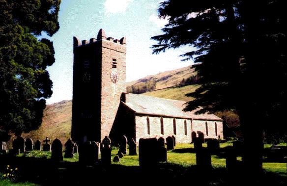
The beams inside are large and it is thought that they may have come from the original, 16th century building. Imagine that, if true it means that wood was first used for building 400 years ago! Guessing that the trees the wood was cut from must have been least 50 years old then the trees themselves first took root about the time when Henry VIII was a young boy.
The stained glass East window was designed in 1873 by a man called Edward Burne-Jones who was helped by two other artists, Ford Maddox Brown and William Morris.
On the opposite side of the main road to the church is the old school, no longer in use.
Back in the main village and moving North from Town End, the next building of interest is the Institute. This building is also one you can go inside. It has a reading room with bookcases lining the walls and curved-back chairs around a large wooden table. By the Institute is the Post Office and village shop. This is about as close as Troutbeck gets to having a village 'centre'. There is a wooden seat outside on a small green with a fine view.
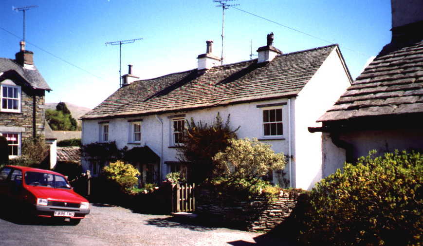
The picture above is of an area called Longmire Yeat.
As with Town End there is an individual house which bears the name of the hamlet. This house has an inscription on its chimney stack- 'GB1649'. I wonder if GB was George Browne? This hamlet is named after the Longmire family who, like the Brownes were an old Troutbeck family. There is a Margaret Longmire buried in the churchyard. She lived to be 104 and was buried in 1868.
Incidentally the word 'Yeat' is old dialect meaning 'gate'.
Another new bit (23rd April 1998)
Moving further to the North end of Troutbeck we reach High Green and The Mortal Man Inn. This itself is a fairly famous local curiosity and has a well known rhyme associated with it:
What is it makes thy nose so red?
Thou, silly fool that looks so pale,
'Tis drinking Sally Birkett's ale!
February 2000- One of our spendid students, Charlotte Lavin, has been researching the history of this area and has come up with a different tale about this fascinating pub. The following is an extract from Charlotte's email..
the Mortal Man...I asked around and apparently it has always been called the Mortal Man. The story goes like this......
A giant man once lived in the foothills of Wansfell. He use to walk
through the village of Troutbeck. One cold winter he perished on Wansfell
and rolled down the fell, and where he came to rest the Mortal Man was
built. He is said to be buired in the foundations.
This is what the people at the pub said anyway...sadly it's a bit tacky for me!
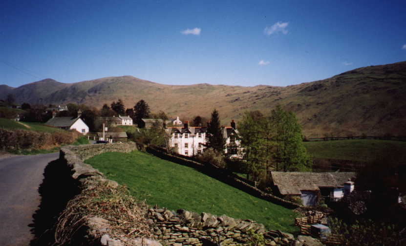
The Inn is the large white building in the centre of the picture. The fell peaks are, from left to right, Froswick (720m), Ill Bell (757m), Yoke (706m) and as the skyline dips slightly, the Garburn Pass which is the old road connecting Troutbeck with Kentmere. Garburn is a rough track which is now a popular route for walkers and mountain bikers.
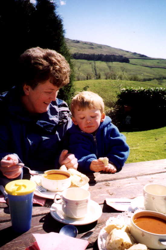
Finally, at least for the moment, a picture of Mandy and Thomas Rhodes enjoying a bowl of soup in the garden at The Mortal Man. In the background is the West side of the valley and the dark lines are the stone walls which line two tracks. The upper one which appears almost level, is Dubbs Road and the lower one climbing the fell side, is Longmire Lane. the two join together at the North end of that plantation of trees and they become the Garburn Pass.
Thanks to Stephanie for the inspiration to get this far. If anyone else would like to add anything or ask us for any more specific information, our email button is on the  Lakes School Home Page
Have a look also at Lakeland Cam A web site created by Troutbeck Bridge postman Tony Richards. Each day as he sets off on his round from Troutbeck Bridge up to the Langdale valley he takes his digital camera with him and grabs a picture as the mood takes him. The picture is usually put up on the internet the same day.
Lakes School Home Page
Have a look also at Lakeland Cam A web site created by Troutbeck Bridge postman Tony Richards. Each day as he sets off on his round from Troutbeck Bridge up to the Langdale valley he takes his digital camera with him and grabs a picture as the mood takes him. The picture is usually put up on the internet the same day.